 Geography
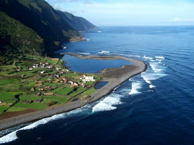
The Archipelago of the Azores is composed of nine volcanic islands situated in the middle of the North Atlantic Ocean approximately 1500 km from the European coast and 3900 km from the North American coast. The Archipelago extends along a south east-north-west strip and is encompassed by the longitude of 25º to 31º-15” West and a latitude of 36º-55” to 39º 45” North.
The archipelago is the western border of the European Economic Community and occupies a total area of 2,333 km2. Due to the geographical dispersion of the islands it encompasses an Exclusive Economic Zone of approximately 940,000 km2. The resident population of the nine islands totals 237,000 people.
Due to the geographical location of the islands they are divided into three groups based on their relative proximity: the Eastern group including Santa Maria and São Miguel, the Central group including Terceira, Graciosa, São Jorge, Pico and Faial and the Western group including Flores and Corvo. The minimum distance between two islands is 6 km (Pico and Faial) and the maximum distance, approximately 600 km, divide Santa Maria and Corvo.
In 1976 the Azores was granted the status of an Autonomous Region. Self government was instated through an amendment to the Constitution of the Republic of Portugal. The area is now governed by a Regional Government located in the city of Ponta Delgada, São Miguel, and by a Regional Assembly located in the city of Horta, Faial. Members of the Assembly and Government are elected by popular vote. The Portuguese Government is represented by the Minister of the Republic who maintains residency in the city of Angra do Heroismo on the island of Terceira.
The archipelago’s location in the north Atlantic brings it in constant contact with both the high pressure areas common to the North Atlantic and the constantly moving polar and tropical air masses.As the European continent is over 1500 km away oceanic conditions are the controlling factors of the regional climate. Consequently the Azores has a temperate, maritime climate characterised by agreeable temperatures with small average annual variance.
A high level of humidity (77% average/yr.), and rainfall which is both regular and well distributed throughout the year, although with greater abundance during the winter months, are the dominant weather patterns in the region.
Light cloud cover is common throughout the year. The annual median air temperature is approximately 17ºC (63ºF), varying between 13º and 14º C (55º-57ºF) during the colder months (January/February) and 22º-23ºC (72º-73ºF) during the warmer months (July/August). The ocean temperatures oscillate between 14º-15ºC (57º-59ºF) during the coldest month (February) and between 22º-23ºC (72º-73ºF) in August largely due to the warming effects of the Gulf Stream that passes this area.
Constituído por nove torrões vulcânicos dispersos no meio do Atlântico Norte, distando cerca de 1.500 Km da costa ocidental europeia e a aproximadamente 3.900 Km do continente norte americano, o Arquipélago dos Açores estende-se por uma faixa, orientada no sentido Sudeste-Noroeste e enquadrada pelos meridianos 25º-31º 15’ de longitude Oeste e pelos paralelos 36º 55-39º 45’ de latitude Norte.
Considerados a fronteira ocidental da CEE, os Açores ocupam uma área total de 2.333 Km2 albergando uma população residente à volta dos 237.000 habitantes e, dada a dispersidade geográfica das suas ilhas, abrangem uma Zona Económica Exclusiva de cerca de 940.000 Km2.Dada a proximidade geográfica inter-ilhas, agrupam-se estas em três grupos diferentes, nomeadamente, o Grupo Oriental constituído pelas ilhas de Santa Maria e São Miguel, o Central integrando a Terceira, Graciosa, São Jorge, Pico e Faial e, finalmente, o Ocidental que engloba as ilhas das Flores e Corvo, sendo a menor distância entre ilhas de cerca de 6 Km, Faial-Pico e a maior rondando os 600 Km, Santa Maria ao Corvo.
Reconhecidos desde 1976 como Região Autónoma, os Açores são geridos, segundo a Constituição da República Portuguesa, por um governo próprio, representado pelo Governo Regional sediado na cidade de Ponta Delgada, na Ilha de São Miguel e pela Assembleia Regional, com sede na cidade da Horta, Ilha do Faial, orgãos democráticos eleitos por sufrágio universal, sendo a soberania portuguesa em solo açoriano representada por um Ministro da República com residência permanente em Angra do Heroísmo, na Ilha Terceira.
Clima
Localizado à latitude dos centros de altas pressões do Atlântico Norte em permanente contacto com as massas de ar, ora polar ora tropical e a cerca de 1.500 Km do continente que lhe fica mais próximo, o Europeu, o efeito da continentalidade não tem qualquer significado no clima local onde, pelo contrário, se faz sentir a grande e constante influência das águas do Oceano.
Como tal, os Açores apresentam um clima temperado marítimo caracterizado por temperaturas amenas com pequenas amplitudes térmicas anuais, elevada humidade relativa do ar (77% média/ano), céu geralmente encoberto, mas com fraca nebulosidade e por uma pluviosidade mais ou menos regularmente distribuída ao longo do ano, embora com maior abundância nos meses de Inverno.
A temperatura média anual do ar ronda os 17ºC (63ºF), variando entre os 13º-14ºC (55º-57ºF) de média nos meses mais frios (Janeiro/Fevereiro) e os 22º-23ºC (72º73ºF) nos mais quentes (Julho/Agosto), enquanto que as temperaturas das águas do mar, devido sobretudo à passagem nesta zona do Atlântico de uma ramificação da corrente quente do Golfo, oscila entre os 14º-15ºC (57º-59ºF) no mês mais frio (Fevereiro) e os 22º-23ºC em Agosto.


.jpg)



.jpg)







No comments:
Post a Comment